Skip to content

The Line: Coveted Chinese Wall Finally Climbed

General News
1 1 136 1
  • The west face of Seerdengpu, a towering rocky summit of 5,592 meters in China’s Siguniang National Park, had been attempted at least a dozen times without success. Among others, West Virginia climber Pat Goodman tried six different lines during three separate expeditions. In 2024, a Chinese climber finally topped out on the 850-meter face, in his fourth year of attempts. Unable to secure a permit, he climbed alone and in secret in August 2024, completing only the second known ascent of the peak. Below is his story.
    In 2015, when I first saw Seerdengpu (5,592m) from the west, I never thought that one day I would stand on the summit. The ca 850m west face was one of the great unclimbed walls of Siguniang National Park and had been attempted many times, notably by American Pat Goodman. In 2013, with Matt McCormick, he made unsuccessful attempts on three different lines, then later another attempt with Marcus Costa, and another, more toward the southwest, with David Sharratt. Costa made another attempt with Enzo Oddo. The face had also been tried by Russian, Australian, Polish, and Chinese teams. Loose terrain and objective danger appear to have been a common problem. 
    Until 2024, Seerdengpu had only one ascent. In 2010, Dylan Johnson and Chad Kellogg (both USA) climbed the northeast ridge (see note below). Prior to their ascent, four parties had attempted the north face.
    I first tried the west face in August 2021 but chose a poor line and retreated after 80 meters. In 2022, I changed to the previously attempted line on the right side of the wall (the line attempted by Costa and Goodman, as well as the Russian and Chinese teams). I retreated after 350 meters. Over three weeks in July 2023, I only reached 200 meters up the same line. I returned in August 2024. 
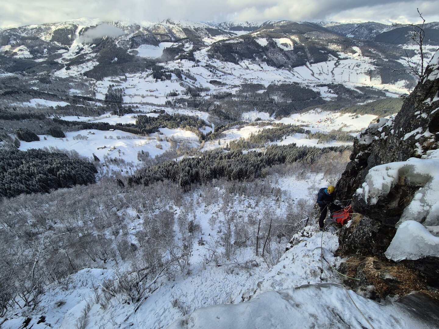
    Unable to get an official permit, I had to work alone, as porters did not dare provide service. [Because of this, the author is using an alias.] I entered the valley several times as a tourist, each time carrying a 40-liter bag. In the end, I ferried a total of 75kg of equipment from the road in Shuangqiao Valley to my base camp at 4,500 meters. 
    After the initial 170 meters of the face, which is 5.7, the route enters a gully. It is always wet. Some previous attempts had failed due to the volume of water, and in 2015 Costa and Oddo tried this route in January, finding the gully nicely frozen but the rock above dangerously loose. They retreated from the Russian high point. I kept mostly in the bed of the narrow gully, which was wet and loose, but easier (5.8 C1+). I made my first portaledge camp at the top of the gully at around 5,100 meters.
    On the first day above the portaledge, I climbed 80 meters at 5.9 C1+. When I rappelled to the ledge that evening, I found two holes in the fly, one of them large. A small bag on the ledge had also been hit and damaged. The next day, I climbed up left on loose but easy rock (5.6), found a site for my next camp, and spent all the following day moving my equipment to Camp 2 (5,250m).
    On August 24, I aided a horizontal crack and took the only fall of the route. I retreated and took a different line, a corner with a thin crack that evolved into a chimney. It was a brilliant 60m pitch at 5.9+ C2. (I suspect it would go free at 5.11 or 5.11+.) Above this, I traversed left using all my 70m rope, then went back to the portaledge for the night. I found it difficult to sleep due to the cold, and perhaps the excitement of being close to the top. 
    On the 25th, I regained my high point and continued up at 5.8 C1+. That day I dropped an ascender, a Camalot, and a sling. I realized that I was losing concentration and needed to be more careful. That night, I didn’t get to sleep until 3 a.m. I was sick and cold. I left Camp 2 again at 8 a.m. on August 26—a total of 27 days since I first started ferrying loads from the road. I reached my high point at 11 a.m. and climbed for a further 150 meters to the top of the face. From there I walked 200 meters over ice and boulders to reach the highest point of the mountain, at 2:55 p.m., for its second ascent. 
    Unfortunately, just 50 meters before reaching the summit, a loose boulder fell onto my left foot and broke a toe. As I started back down, it began to rain. Four hours of rappelling thr...


Suggested topics


  • New 19-Pitch 5.11 on Mozambique Mountain

    General News climbing
    1
    0 Votes
    1 Posts
    106 Views
    GrippedG
    The new 890-metre climb is the first rock route established on the granite monolith The post New 19-Pitch 5.11 on Mozambique Mountain appeared first on Gripped Magazine. https://gripped.com/news/new-19-pitch-5-11-on-mozambique-mountain/
  • Speed finals | Chamonix 2025

    Videos climbing ifsc
    1
    0 Votes
    1 Posts
    104 Views
    IFSCI
    https://www.youtube.com/watch?v=yhN_bwiFk_E
  • Climbers Bag Speed Records on Mont Blanc

    General News climbing
    1
    0 Votes
    1 Posts
    174 Views
    GrippedG
    The women's and men's speed records on Grand Mulets were recently set by two French climbers The post Climbers Bag Speed Records on Mont Blanc appeared first on Gripped Magazine. https://gripped.com/news/climbers-bag-speed-records-on-mont-blanc/
  • How to be fast and efficient when clipping

    Videos climbing
    1
    0 Votes
    1 Posts
    174 Views
    EpicTVE
    https://www.youtube.com/watch?v=KIj9bOKhnoo
  • 0 Votes
    1 Posts
    146 Views
    UK ClimbingU
    The route, his third at 9a+ in 2024 alone, was first climbed by Alex Megos in 2016, but is best known for its second ascent, when Adam Ondra became the first person ever to flash a route at 9a+. https://www.ukclimbing.com/forums/t.php?n=777086
  • 0 Votes
    5 Posts
    431 Views
    RaykoR
    Important information about the dos and don'ts on THE most important knot in #climbing and some myth busting.And here I thought it was all tested and proven about the humble figure eight.I've never used that yosemite finish, and I don't think I'll ever will. The stopper knot in the tail is enough and it doesn't really bother me particularly.I actually do like tails but that a whole different conversation https://youtu.be/nUCR_W-xCqY?si=3-A-1FABJ_4LWmht
  • 0 Votes
    1 Posts
    184 Views
    American Alpine ClubA
    Mark Westman has been climbing in the Alaska Range for nearly three decades and was a Denali Mountaineering Ranger for ten years. He has attempted Mt. Russell, on the southwest edge of Denali National Park, three times by three different routes over 27 years. The third time was the charm, as he and Sam Hennessey raced to the summit in a single day in late April. It was only the ninth ascent of the 11,670-foot peak, and Westman believes the line they followed may be the most reliable way to reach this elusive summit. At 9:45 a.m. on April 27, Paul Roderick dropped Sam Hennessey and me on the upper Dall Glacier, directly beneath the nearly 6,000-foot-tall east face of Mt. Russell—our objective.   We had in mind a rapid round trip. After quickly setting up a tent to stash food and bivouac gear, we departed half an hour after landing with light packs. We started up the left side of the east face, following the same line that Sam had climbed the previous spring with Courtney Kitchen and Lisa Van Sciver. On that attempt, they carried skis with the hope of descending off the summit. After 3,600 feet of snow and ice slopes, they reached the south ridge, which they found scoured down to unskiable hard ice. They retreated and skied back down to the Dall Glacier. The route Sam and I followed on the east face steepened to 50° at about mid-height, and the snow we had been booting up gave way to sustained hard névé and occasional ice—much icier conditions than what Sam and partners had found at the same spot in 2023. We continued to a flat area at 9,600 feet, near the base of the upper south ridge of the mountain. Until this point, we had climbed unroped for most of the way. The upper south ridge was the route followed by Mt. Russell’s first ascent team in 1962 (see AAJ 1963). They accessed it from the west side via an airplane landing on the Chedotlothna Glacier (which is no longer feasible because of glacial recession). This section of ridge was repeated by Dana Drummond and Freddie Wilkinson in 2017 after they pioneered a new route up the direct south face and south ridge of Russell (5,000’, AK Grade 4; see AAJ 2018). From where we intersected the ridge, there were several tricky sections of traversing across 50° ice and knife-edge ridges. We used the rope for these parts, then continued unroped for several hundred feet, easily avoiding numerous crevasses. Just beneath the summit, we reached a near-vertical wall of rime ice, surrounded by fantastically rimed gargoyle formations that spoke to the ferocious winds that typically buffet this mountain. We belayed the short bulge of rime and minutes later became only the ninth team to reach the summit, just seven hours after leaving our landing site. The peak known today as Mt. Russell appears to have been called Todzolno' Hwdighelo' (literally “river mountain”) in the Upper Kuskokwim Athabascan language. This is according to a National Park Service–sponsored study of Indigenous place names written by James Kari, professor emeritus of linguistics at the University of Alaska. Today’s Mt. Russell was named for geologist Israel Cook Russell—one of founding members of the AAC. The California 14er Mt. Russell is also named for him. There wasn’t a cloud in any direction and not a breath of wind. I had made storm-plagued attempts on Russell in two different decades, and there were many other seasons where I had partners and dates lined up but never left Talkeetna due to poor weather. It was truly gratifying to reach the top of this elusive summit. Sam and I descended to the landing site in just four hours, making for an 11-hour round-trip climb and the mountain’s first one-day ascent. Paul picked us up the following morning. While all of the terrain we followed had been climbed previously, the east face and south ridge had not been linked as a singular summit route. Having attempted the now very broken northeast ridge in 1997, and having climbed most of the Wilkinson-Drummond route in 2019, I feel... https://americanalpineclub.org/news/2024/9/3/the-line-mark-westman-mt-russell-and-more
  • IFSC Lead and Speed World Cup Brianon - Report

    General News climbing
    1
    0 Votes
    1 Posts
    195 Views
    UK ClimbingU
    The next round of the IFSC World Cup took place in Brianon last weekend. As the last event before Paris 2024, many qualified athletes chose to sit this event out, but a few used it for some last-minute practice. The Speed discipline ha... https://www.ukclimbing.com/forums/t.php?n=773179